

Vidar
Continuous navigation when GPS fails, degrades, or cannot be trusted
Aviation Navigation Capabilities
GPS Was Never Designed to Be the Only Answer
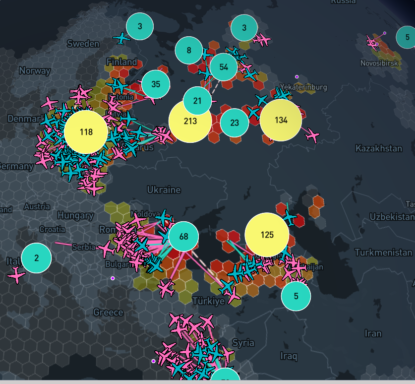
GNSS interference is no longer theoretical. In 2024 alone, thousands of aircraft reported navigation anomalies caused by jamming and spoofing near conflict zones, across the Eastern Mediterranean, the Baltic, and increasingly over Western Europe. Airlines are already downgrading approach procedures.
Pilots are already reverting to manual navigation. Regulators are already asking what happens next.
The backup systems currently available, – inertial navigation, ground-based radio aids, radar positioning – were designed for a different era. INS drifts within minutes. VOR/DME coverage is shrinking. None of them were built to detect that interference is happening, let alone identify where it is coming from.
The aviation industry has a gap: not just in backup navigation, but in situational awareness of the threat itself.
A Passive Navigation Layer That Requires No Ground Infrastructure
Vidar is a self-contained positioning system built around passive RF sensing. It does not transmit. It does not depend on satellites, ground stations, or any external infrastructure. It observes the ambient electromagnetic environment and derives continuous position estimates from the structure of that environment.
The system is housed as a compact sensor module paired with a processing unit.
On an aircraft, it mounts internally behind the fuselage or nose section and integrates as an auxiliary navigation source alongside existing avionics.
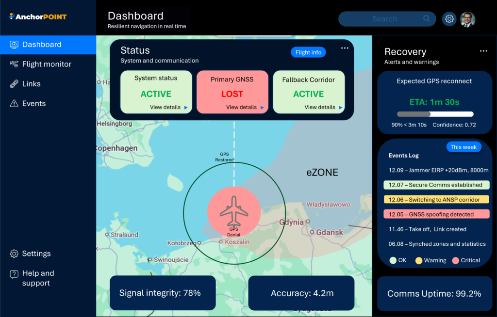
It is running continously and detects when GNSS signals degrade, with no pilot intervention required.
Vidar does not replace GPS. It provides a hardened continuity layer underneath it -one that keeps working when GPS does not.
Capabilities
GNSS-Independent Positioning
Maintains a continuous position estimate using passive observation of the ambient RF environment. No satellite signals, no ground beacons, no external data links required
Automatic Interference Detection
Detects GNSS jamming and spoofing in real time and alerts the flight crew immediately. The system distinguishes between signal loss and active manipulation, providing actionable awareness rather than a simple flag.
Seamless
The transition from GPS to Vidar positioning is seamless. The system monitors GNSS integrity continuously and activates backup navigation
without manual switching or mode selection.
The core positioning algorithms behind Vidar were developed through university-led RF research programmes with over a decade of foundational work.
Conqorde integrates these algorithms into a certified-path navigation product, combining academic rigour with aviation-grade engineering.
This is not speculative R&D. The underlying science is validated. The integration challenge is well-defined.

Multi-Domain Capability
Vidar is designed for aviation first, but the same core technology applies across domains. The sensor architecture is platform-agnostic and can be adapted for maritime vessels and ground vehicles facing the same GPS vulnerability.
Commercial shipping routes through areas of known GNSS interference, road logistics fleets, rail operations, and emergency service vehicles
all face growing exposure to the same problem. Vidar provides a single technology foundation across all three domains.
Engagement
Vidar is in active development with a regulatory certification pathway underway. We are engaging with airlines, aircraft operators, and aviation safety organisations who recognise that GPS resilience is no longer optional.
If you are responsible for navigation safety, fleet operations, or regulatory compliance and want to understand what a passive, infrastructure-
free backup navigation capability looks like in practice, we should talk.

Operational Domains
Civil Aviation
Maintain navigation continuity for commercial airlines, business aviation, and cargo operations when GPS signals are jammed or degraded.
Ground Transportation
Enable navigation continuity for road transport, rail operations, and logistics fleets operating in GPS-denied environments.
Maritime Operations
Provide vessel positioning for commercial shipping, ferries, and offshore operations in waters experiencing GPS interference or spoofing.
Emergency Services
Support air ambulance, search and rescue, coastguard, and emergency response across air, sea, and land operations requiring reliable positioning.
Research-validated technology | Multi-domain capability | Regulatory compliance pathway
Integration Approach
Vidar integrates as an auxiliary navigation source within existing systems across aviation, maritime, and ground platforms. The system interfaces with standard navigation displays and management systems, requiring minimal modification.